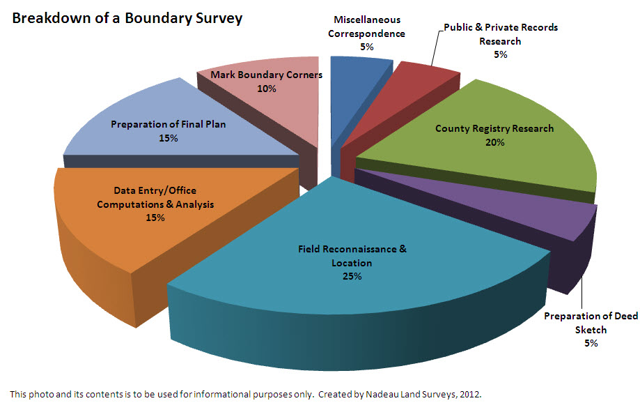
Our Breakdown Is As Follows:
Registry Research – 20%
Perform chains of title at appropriate county registry of deeds. Since a boundary survey depicts the location of record lines created by deed or plan (operative documents) from an original grantor, the order of lot creation in comparison to applicable abutting parcels is required to determine sequence of conveyance, original called for boundary markers, easements, typographical errors, and whether or not deed excess or deficiency exist. For example, a boundary survey of our office would require research for deeds in Portland (post-1899), in Deering (1871-1898), and in Westbrook (pre-1871). In some cases, research may go back to ancient Falmouth (1814), or if pre-1820, into Massachusetts deeds. Within our scope of service, we also perform a second tier of research on the locus parcel(s) from date of transfer to the current date of each grantor, and the heirs of each grantor, to identify record appurtenances not referenced in the chain of title. Through the years, we have found many valuable documents ranging from original deeds recorded seventy years after execution, easements, and rights of way which have greatly impacted our survey.
Private and Public Records Research – 5%
Collect information from appropriate municipal offices, abutters, other land surveyors, state agencies, registry of probate, county commissioners office, historical societies, etc. This effort is required to obtain information not recorded at the registry of deeds. For example, a recent survey we performed in Yarmouth required research at the North Yarmouth Historical Society, since Yarmouth was formally part of North Yarmouth prior to 1849.
Preparation of a Deed Sketch – 5%
A worksheet is created which identifies the various record calls along each boundary line. It is not uncommon for a boundary line to have several different distances or calls for evidence over time. This is why it is crucial to perform research to the original deed, as it often best identifies the intent of the original grantor. A land surveyor will base his or her professional opinion on evidence found relative to the locative information (distances, angles, or bearings) within the deeds. Varying land surveyor opinion is often caused by the level of effort in identifying applicable deeds, plans, or evidence.
Field Reconnaissance & Instrument Location – 25%
Using the deed sketch, we arrive at site with a clear understanding of all evidence called for in the parcel being surveyed and its abutting parcels. Upon completion of our field search, we will field locate all applicable boundary evidence, improvements, and lines of occupation (i.e tree lines, fences, stonewalls). It is not uncommon for occupation lines and records lines to be in a different location.
Data Entry/Office Computation & Analysis – 15%
All data collected is reviewed, validated, and verified for mathematical accuracy to allow for the proper sequence of lot lines created on the parcel being surveyed and its abutting parcels. During this process we determine an accurate acreage, encroachments, boundary corner locations, easement, rights of way, etc. Upon completion, we have created our professional opinion as to the location of the boundary lines surveyed.
Preparation of a Final Plan – 15%
This document depicts the results of all rendered services, final findings and recommendations, and should be worthy of passing scrutiny from by another land surveyor in a discussion or dispute. This product is insured and prepared in compliance to State Board of Licensure minimum requirements.
Mark Property Corners – 10%
A return visit back to site to mark boundary corners and lines for the client with a #5 (5/8") steel rebar with survey cap #2124 (Maine Survey License I.D.). Our survey cap provides notice to abutters and future land surveyors that this parcel has been formally surveyed. Depending on client request, municipal requirements, or field conditions, we could set a granite or concrete monument, "PK" nail, or spike.
Miscellaneous Correspondence – 5%
Communication with client, municipality, or design consultant, as needed.